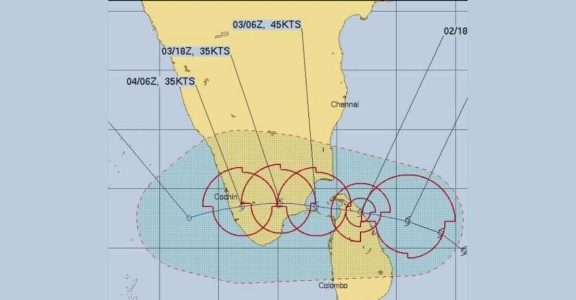
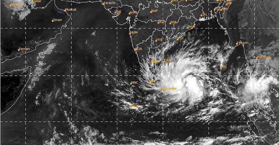
Thiruvananthapuram: Cyclone Burevi, the second cyclone formed in the southwest region of the Bay of Bengal within a week, will weaken and move into the Arabian Sea through southern Kerala on Friday.
Earlier, it was estimated that the wind would move from Kanyakumari to the Arabian Sea via the coast of Thiruvananthapuram. As per latest India Meteorological Department (IMD) update, the cyclone's path has further moved to northward and four southern Kerala districts likely to come under its influence.
District Disaster Management Authority helpline for emergency use – 1077
The IMD has issued Red alert (heavy to very heavy rains of over 20 cm in 24 hours) for Thiruvananthapuram, Kollam, Pathanamthitta and Alappuzha districts and Orange alert (6 cm to 20 cm rain) for Kottayam, Ernakulam, Idukki districts on Thursday. A Yellow alert has been sounded in Thrissur and Palakkad districts.
Winds of up to 60 kmph are expected in Thiruvananthapuram, Kollam, Pathanamthitta and Alappuzha districts on Friday. Some places in Ernakulam and Idukki districts may also face winds of upto 40 kmph.
The Thiruvananthapuram district administration has issued special alert in 48 villages.
Kerala on alert

Authorities have geared up to tackle the situation by opening 2,849 relief camps and taking other steps including banning fishing along the coast till December 5. The state government has also asked the people to avoid travel to high range areas in view of the heavy rain predicted.
Prime Minister Narendra Modi spoke with chief minister Pinarayi Vijayan on Wednesday and assured him of all possible help from the Centre.
"Experts have opined that the Burevi cyclone will reach Thiruvananthapuram by Friday. We have discussed matters related to the cyclone with Prime Minister Narendra Modi. We have explained the steps taken by the state government," Vijayan told the media on Wednesday.
Vijayan said the India Meteorological Department (IMD) has predicted that Thiruvananthapuram, Kollam, Pathanamthitta, Kottayam, Alappuzha, Idukki and Ernakulam districts will receive heavy rains and wind from December 3 to 5.
"Eight teams of the NDRF have reached the state. The facilities of the Airforce have been arranged at Sulur Airforce base in Coimbatore. The Navy is also ready. A State executive meeting, chaired by the chief secretary, has met and assessed the situation," the chief minister said.
Vijayan asked the people not to worry and said the state government has made all arrangements to face the situation.
"There is no need to worry as the state government has opened 2,849 relief camps to accommodate the people who need to be shifted due to the cyclone. Currently 690 members of 175 families have been already shifted to 13 camps," he said.
The chief minister said since heavy rain has been predicted in Pathanamthitta district, restrictions will be imposed for the Sabarimala pilgrimage, based on the weather conditions.
He asked the people of the state to cooperate with the health department which is already burdened with the COVID-19 mitigation work.

Kerala State Electricity Board (KSEB), Kerala Water Authority (KWA) and Civil Supplies Departments have been directed to supply electricity, water and food items to the camps if needed. The Department of Hydrology has been asked to monitor the water levels in the major rivers of in view of the possibility heavy rainfall.
The public had been warned to stay alert towards the damage Burevi likely to inflict on South Kerala. It includes:
• Damage to thatched huts.
• Minor damage to power and communication lines due to breaking of branches.
• Major damage to Kutcha and minor damage to Pucca roads.
• Some damage to paddy crops, banana, papaya trees and orchards.
• Sea water inundation in low lying areas after erosion of Kutcha embankments
Precautions to be taken:
• Move to a safer place in case you're living in a thatched hut or vulnerable area.
• Keep an emergency medical kit ready for immediate use.
• Listen only to official announcements, do not spread rumours.
• Secure the windows of houses and buildings.
• Do not tie pets or keep them in cages.
• For official information visit State Disaster Management Authority website https://sdma.kerala.gov.in/ and IMD website https://mausam.imd.gov.in/Thiruvananthapuram/
Burevi hits Sri Lanka, thousands evacuated
Cyclone Burevi hit Sri Lanka's northeast with heavy rains and gusty winds on Wednesday as it headed toward the interior of the country. The cyclone entered the country off Mullaitivu, 205 miles northeast of Colombo, the capital, and was travelling further inland, Meteorological Department director general Athula Karunanayke said.
The storm was estimated to have wind speeds of 47-53 miles per hour, with gusts of up to 59 mph. The Mullaitivu area received the heaviest rainfall, with about 7.9 inches over the last 24 hours.
More than 500 families have already been displaced due to heavy rains and strong winds, which have left trees uprooted, roofs blown off and some areas inundated.
As a precaution more than 10,000 people were being evacuated from the eastern coastal districts of Mullaitivu, Trincomalee and Batticaloa to safer areas, while fishermen have been directed to keep out of the sea, Disaster Management Centre officials said.
Tamil Nadu braces for another storm

The IMD said from Sri Lanka, the cyclone is "very likely" to move nearly west-northwestwards, emerge into Gulf of Mannar (near the southeastern tip of India) and adjoining Kanyakumari by the morning of December 3.
This is the second cyclone that is predicted to hit Tamil Nadu in a week. Last week, a very severe cyclonic storm, Nivar, had battered the southern state.
By December 3 noon, Burevi will be centred over Pamban with a wind speed of 70-80 km/hr and gusting to 90 km/hr. "It would then move nearly west-southwestwards across Pamban area by afternoon and cross south Tamil Nadu coast between Pamban and Kanyakumari during the night of December 4 and early morning December 5 with a wind speed of 70-80 km/hr gusting to 90 kmph."
The IMD bulletin said Burevi's impact on south Tamil Nadu coastal districts was very likely to commence from the forenoon of December 3, initially over Ramanathapuram district and gradually towards Kanyakumari district.
What is of relief is that the cyclonic storm would lose speed as it passes over land. When it enters Sri Lanka, it is expected to have a speed of 80-90 km/hr. But as it crosses Tamil Nadu, the speed would lessen to 70-80 km/hr.
The storm is expected to cut through Kerala on December 4 and by then its speed would have reduced to 50-60 km/hr.
Meanwhile, teams from National Disaster Response Force (NDRF) have been sent to Kanniyakumari, Tuticorin, Tirunelveli and Madurai, the state government has said. In Nagercoil, relief camps are being set up.
(With inputs from PTI and IANS)


