


You won’t find the route to Mampazhathara viewpoint on Google Maps. However, a charming forest path through some very picturesque areas would take you to the village of Mampazhathara in the middle of the woods. Located near Thenmala in Kollam district of Kerala, Mampazhathara is an ideal destination for a one-day trip.
Most travellers are familiar with the attractions on the Kollam - Punalur - Thenmala route, including the hanging bridge in Punalur, the Kannara Bridge on the Punalur - Shencottah railway track and the forest as well as ecotourism centre in Thenmala. By planning a two-day outing, these spots too could be covered along with Mampazhathara.

The railway track passing near the road has now been upgraded to broad gauge from metre gauge. However, the once-beautiful and historic Kannara Bridge looks ugly after getting a coat of cement.


The route
While travelling to Mampazhathara from Thenmala, take the Kerala - Tamil Nadu road and pass through the tunnel under the Kazhuthurutty railway station. On the other side of the tunnel, continue along Ambanad Hills Road, which cuts across several estates. Soon, your vehicle would reach a tri-junction named Nedumbara. From here, take the deviation to the left and a visual feast awaits travellers.
The path is flanked by hills where pineapple is grown and some distance away from another hill covered with thick greenery comes into view. This is the Sanyasimala.
Green slopes behind tile-roofed buildings remind one of the sceneries of Munnar. The scenery of the barren hills is much similar to Vagamon and Ooty also.

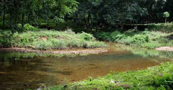
The main attraction of a trip to Mampazhathara is this route, rather than the sights at the forest village. A gentle brook flows on one side of the path and one can safely attempt a dip as the water is not deep. Moreover, the water is clear and pure.
Interestingly, even though this track is mostly deserted these days, it was the main route from Aryankavu to Thiruvananthapuram in the past. During those days, the Thenmala - Punalur road was yet to be built. Local people would inform you that during its heyday, the road was lined on both sides by mango trees, earning the village the name of Mampazhathara, or the place of ‘mambazham’ (mangoes).
The path continues along with more estate lands. On Google Maps, a spot called Mampazhathara could be seen, but the route won’t be marked. This invisible route is the most beautiful part of a journey to the forest village. The path is similar to a steep ghat road with thick forest on both sides. One may even hear wild elephants breaking forest trees. There are indeed elephants in the area, local people would warn you.
After a curve, the road goes downhill. Some distance in front, a clearing made in the forest to plant pineapple would be seen. This earthy hue between the blue hills indicates that Mampazhathara is ahead. Except for the area where the village stands, overwhelming greenery dominates.
Meanwhile, the path passes close to the thick woods with vines that can hide even an elephant. For some distance, the track passes through ‘shola’ forest. It is tempting to get off the vehicle here as the darkness and chill are inviting. But, it is better to avoid taking a stroll.
All along the route, uprooted trees and big rocks lying on the road. Soon, you will reach the spot where greenery has been removed to grow pineapples. Electric fence to ward off wild elephants has been erected in the area. More quarters of estate workers come into view. Even the rubber estates have a peculiar charm in Mampazhathara, a village scattered in the forest.
The path touches Nagamalai estate and curious name boards such as Kuravanthavalam are seen. There is also a stone temple named Sri Bhagavathy Amman Kovil. Believed to be at least two thousand years old, the temple is surrounded by the forest. However, the interiors of the shrine offer safety from the wild with even the windows being made of stone.
There are several carvings and ancient inscriptions on the temple walls. According to local people, the temple was built by Saurashtrians who reached the area from Tamil Nadu. While urging the Archaeology Department to research the temple, the residents say that the deity is Pushkala Devi, who is considered to be the bride of Lord Ayyappa.
The path beyond the temple runs into much more dense forest, which is part of the Achenkovil woods. It is better to start the return journey from here. The temple area is rich in avian wildlife as many rare species such as hornbills could be spotted.
Driving back, you can turn to the popular spots such as Palaruvi waterfalls and Thenmala ecotourism centre from Kazhuthurutty.
Travel tips
The distance from Ernakulam to Punalur is 165 km. Punalur to Kazhuthurutty is 26 km and from there to Mampazhathara is another eight km.
Mampazhathara is part of the Thenmala grama panchayat in Kollam district.
For a smooth trip, drive without stopping along the way. However, as there are no boarding facilities at Mampazhathara, look for accommodation at Thenmala or nearby places.
Buy food from Thenmala and don’t litter Mampazhathara.

Plan your trip so that the return journey could be started at noon as driving through the estate road in the evening is dangerous. Fill enough fuel in your vehicle from Thenmala or nearby.


