65 landslides across Kerala this year so far, Palakkad tops list

Mail This Article
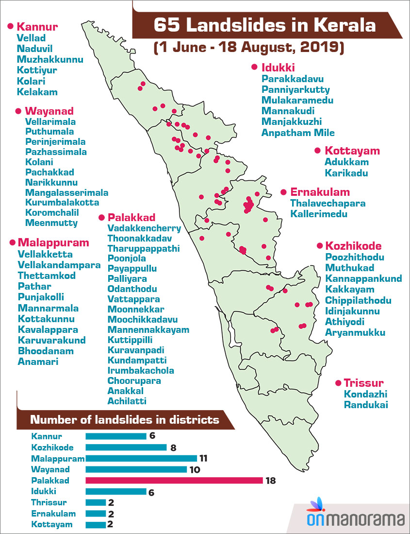
Thiruvananthapuram/Malappuram: In all 65 landslides of varying magnitudes occurred across Kerala during this monsoon. This figure was arrived at by the Kerala State Remote Sensing and Environment Centre (KSREC) using data collected by the state disaster management authority.
Palakkad tops the list of districts with most landslides (18), followed by Malappuram (11).
The Geological Survey of India had earlier identified 14.4% of the state’s regions as vulnerable to landslides. Mapping experts at the Kerala State IT Mission have been asked to ascertain whether landslides were reported from areas mentioned in that report.
The KSREC is currently mapping areas affected by floods.
A KSREC report had identified 270 areas where landslides occurred during last year’s floods, including 180 in Idukki district alone. Malappuram reported 30 and Kannur district 17 landslides then.
NGRI team at Kavalappara
Meanwhile, a team of experts from the Hyderabad-based National Geophysical Research Institute (NGRI) arrived at Nilambur in Malappuram district on Saturday to help with the ongoing search operations at Kavalappara, the worst-hit landslide spot in Kerala.
The NGRI personnel, armed with ground penetrating radar (GPR) system, will give inputs to the rescue personnel at Kavalappara to locate those likely trapped under the landslide debris.
With two more bodies recovered from here on Saturday, the toll reached 50. According to officials, 19 people are still missing from the area.
Meanwhile, the district administration has rubbished rumours that the search operations at Kavalappara have been stopped.
The mission will continue till the last of the victims is found, it said.
What is Ground-Penetrating Radar?
A ground-penetrating radar (GPR) is an instrument designed to detect patterns of electromagnetic waves in the soil. The device contains a transmitting antenna and a receiving antenna, which allows it to send and detect electromagnetic waves at given frequencies.
GPR sends high-frequency (usually polarised) radio waves into the surface. When the wave encounters a buried object or a boundary between materials having different permittivities ('permiitivity' is the measure of the ability of a material to interact with an electric field and become polarised by the field), it may be reflected or refracted or scattered back to the surface. A receiving antenna can then record the variations in the return signal. By this process, the experts can determine if there is anyone trapped under the debris in a specific area.
The principles involved are similar to seismology, except GPR methods use electromagnetic energy rather than acoustic energy.