Why is 'drought of 2016' unlikely to be repeated in 2023

Mail This Article
Last time when there was drought in 2016, Kerala had better rains than now.
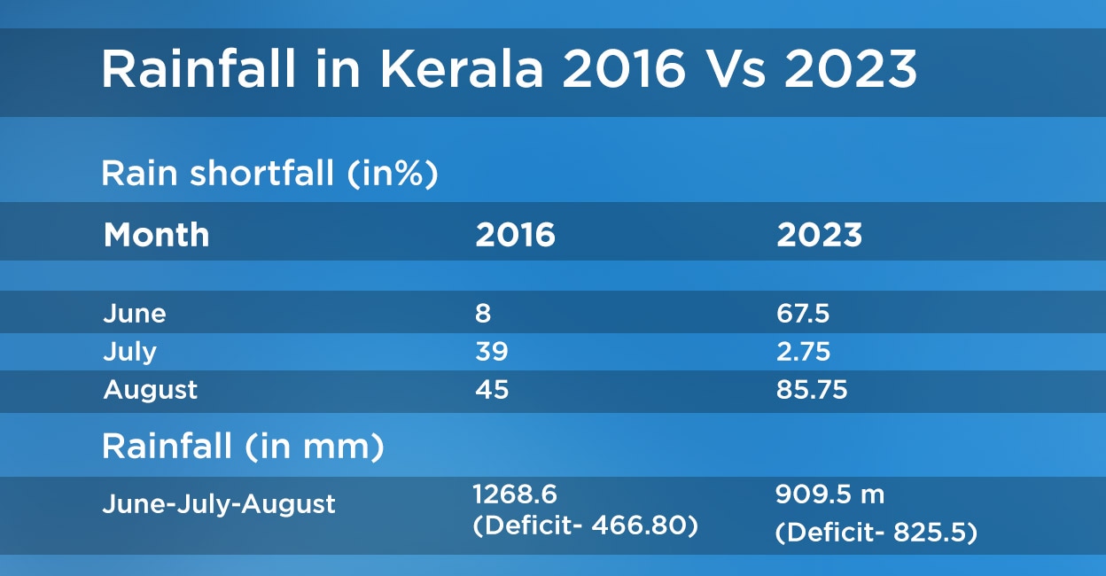
In June 2016, the shortfall was just a marginal 8 per cent. This June, the rainfall deficit was nearly eight times that, 60.75 per cent, which in meteorological terms is called "large deficient".
In July 2016, the shortfall was 39 per cent, far worse than now. This year, because of the fairly heavy rains in the first and the third weeks of July, the deficit was only 2.75 per cent.
However, the sudden disappearance of rains during August has given rise to speculation that 2023 could be worse than 2016.
In August 2016, the monsoon shortage was alarming: 45 per cent. In retrospect, the deficit seems mild. This August, the shortage is a whopping 85.75 per cent.

In 2016, the monsoon months of June, July and August together gave Kerala 1268.2 millimetres of rain, far less than the 1735 mm required. This time, the three months together gave just 909.5 mm.
Nonetheless, there is relief in the sudden revival of rain in September. Till August 31, there was a shortage of 48 per cent. However, in four days, the deficit has marginally dropped to 46 per cent.
Though the 2016 monsoon fared better than this year, what pushed the year into drought were the arid months of September and October. The deficit was 66 and 64 percent, respectively.
Meaning, if the current spell of September rain does not sustain, Kerala will find itself in the grip of a drought far more severe than in 2016. But, there are three reasons why the spell could be sustained at least till the middle of September and avert a drought.
Positive atmospheric flow
One, the Indian Ocean Dipole (IOD) is moving towards positive.
Imagine a line on the Indian Ocean below India with two ends, the west pole and east pole. The IOD is positive when the temperature is hotter on the west side and colder on the east side.
"The IOD has to be positive for Kerala to get monsoon rain. During August, the IOD was neutral," said M G Manoj, a scientist at the Advanced Centre for Atmospheric Radar Research, CUSAT.
So when the 'west pole' becomes warmer, or the IOD becomes positive, atmospheric winds from the east side will flow to the west, nearer the Kerala coast. This cold air will be heated by the rising hot air on the west forming rain clouds along the Kerala coast as a result of convection.
Low pressure boon
Two, low pressure areas are forming in the Bay of Bengal, a prerequisite for rains during monsoon.
"Low pressure formations are common during this time of the year as the sun is right on top of the Indian peninsula. On September 21, the sun will be right on top of the equator on its way south," Manoj said.
This heats up ocean surfaces, causing the formation of low pressure areas. These low pressure areas, which will gradually develop into deep depression and then cyclones, will pull cold winds from the west towards it causing rain along the Kerala coast.
The India Meteorological Department (IMD) bulletin on Monday (Sept. 4) said the cyclonic circulation over Northeast Bay of Bengal could develop into a "low pressure area" soon.
Moving cloud train
Three, a phenomenon called the Madden Julian Oscillation (MJO), as part of its perennial circling around the earth, has pulled away the "nonconvective" or no-rain clouds away from India.
The MJO is an eastward moving cloud band, a perpetually moving cloud formation that, in miniature, can resemble a bracelet made of stones of various shapes and colours. In this cloud band, a patch of rain cloud follows a patch of no-rain cloud and so on, and in between there would be neutral patches. By the end of August, a no-rain patch of cloud over India has been replaced by a neutral patch of the MJO.
This MJO patch, though neutral, is not a threat to the continuance of monsoon.
Disruptor in chief
Nevertheless, the El Nino phenomenon that had smothered this year's monsoon and disrupted the global atmospheric pattern is still active. It is just that these three favourable conditions have begun to nullify its effect.
El Nino, like the IOD, is also about the difference in ocean temperatures at two ends. If IOD happens in the Indian Ocean, El Nino occurs in the Pacific Ocean.
"The temperature over the central to east-central part of the Pacific Ocean becomes anomalously high during an El Nino year. This causes hot air to rise up creating a low pressure area in the central and east Pacific areas near the equator. This would cause cold atmospheric winds from the high-pressure western side of the Pacific, nearer to India, to move eastwards," Manoj said.
As a result, areas that were bound to receive rainfall during the season, like India, will be left dry and places like Peru in South America, which are usually bereft of rains during this time, will be soaked.
El Nino's gift
There is yet another reason why atmospheric scientists are hopeful that 2023 will not be a drought year like 2016. "It has been statistically observed that during an El Nino year the chances of a healthy north-east monsoon are high," said Manoj. 2016, when the north-east monsoon betrayed Kerala, was not an El Nino year.


