Adukka Fort: a crumbling citadel wrapped in mystery

Mail This Article
Which is the northernmost fort in Kerala? According to the book Kasaragode Charithravum Samoohavum published 18 years ago, it is the Arikkady Fort in Kumbla. However, facts prove otherwise. There is another fort which is strategically placed to thwart attacks from sea and land alike.
Evidence of this could be found at Shiriya village in Mangalpady where the remains of the Adukka Fort exist. Documents of the revenue department show that the area of the fort is 6.07 acre. But historians have made no effort to correct the facts given in the book published by the district panchayat even after 18 years. The book explains that the forts in Kasaragod are situated along two directions. One is from Kumbla to Mattlayi (Cheruvathur) and the other from Bandadukka to Bekal. In old records there are references about a fort at Manjeswaram, but no remains of such a structure is there now. Even after all this, Adukka Fort and its history remain hidden.
Inaccessible fort
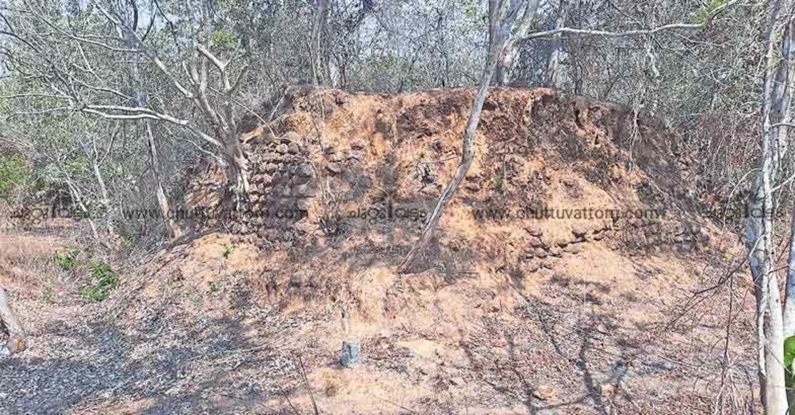
In olden days, this fort on the high grounds would have toughly resisted invasion raids by enemies, it still does but in a non-violent way. Though as per the documents of revenue authorities the Adukka Fort is on the banks of the Shiriya River, the actual location of the fort is not known. The fort now sits camouflaged behind thick vegetation making it inaccessible.

While revenue records say that the fort extends to 6.07 acre, its real area is 8.40 acre, claim the natives. They are, however, relieved that at least 6.07 acres could be saved as it is revenue land. Several forts in Kasaragod have been encroached. People residing in the neighbourhood say that the fort has several wells, moats and tunnels leading to the Shiriya River.
Abandoned and entry restricted by vegetation, ants have made the fort their stronghold. One could find several ant hills inside the fort now.
Traces of the fort's valiant past is still visible in the form of signs of cannons that once trained its muzzle on intruders. The strategically placed gaps on the fort wall for firing the cannons are still intact. The fort wall has been built using carved granite and laterite stones. Around the fort is a moat which is two metre in depth and width. Adjacent to this moat is the wall reaching up five metre. It is not just weeds or bushes that have invaded the fort, there grow several medicinal plants as well.
Though many structures have collapsed, there are numerous signs of the fort having been used by soldiers. However, the authorities are showing no interest to launch restoration efforts.
Strategic importance
The fort also offers a scenic view of the surrounding area. One is that of the Shiriya River, flowing close to the fort, merging with the sea 2 km away. The greenery of Ichilamkodu, Bambrana and Shiriya areas can also be enjoyed. Another unique feature of the fort is that it offers view of both the sunrise and sunset. Today, the fort and its vicinnity serve the purpose of sightseeing, but it was once crucial for those who built it. From here the occupant could hold off an attack from sea and from the land without major shift to artillery.
Adukka Fort is situated between Arikkady Fort and Bandiyode. The place is 1.5 km east of Muttom on the national highway and north east of the Shiriya river.
Origins of the fort
Malar Jayaram Rai, a former teacher and journalist, estimates Adukka Fort's age to around 700 years. ‘Thottampattu’, the folk songs prevalent in the area, relate several battles between the natives and the Portuguese. This was when all commerce took place through water bodies. The fort was built during the time of either Kethali dynasty or Ikkeri dynasty. Descendants of Ramakshatriya and Kottayoru communities still live at Batherikkal beach. Historians believe that the ancestors of this family were brought to the area to protect the fort.
Right next to the fort is a ground, which might have been utilised to train horses for war. This area is a private property now.
Public activist Abdul Rahman Bandiyode says the original area of the fort was 8.40 acre. Demands to protect the fort and the surroundings and develop them into a major tourist attraction have been raised. A project report for the purpose has been submitted to the district panchayat, said Mangalpady panchayat president Shahul Hameed Bandiyode.

